


687
Maps of Iraq
Maps of Iraq. 1929
Schätzung:
€ 200 Ergebnis:
€ 168 (inkl. Käuferaufgeld)
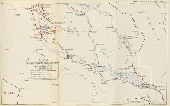
Maps of Iraq. With notes for visitors. Revised and enlarged edition. Mit 1 fotogr. Frontispiz und 8 farb. Faltkarten . Bagdad & London 1929. OLwd. Gr.-4to. 2 Bll., 34 S. (Text)
Seltener Irak-Atlas aus dem Jahr 1929. - "The notes for visitors herein should not be regarded as necessarily containing the official views of the Ministries of the Government. The maps in this book were printed to illustrate the 1924-1927 report of the Public Works Department." (Titelblatt) - Text tlw. etw. fleckig und mit einigen Eintragungen; Einbd. berieben.
Seltener Irak-Atlas aus dem Jahr 1929. - "The notes for visitors herein should not be regarded as necessarily containing the official views of the Ministries of the Government. The maps in this book were printed to illustrate the 1924-1927 report of the Public Works Department." (Titelblatt) - Text tlw. etw. fleckig und mit einigen Eintragungen; Einbd. berieben.
Weitere Informationen
Empfehlen
 +Link zum Teilen
+Link zum Teilen
687
Maps of Iraq
Maps of Iraq. 1929
Schätzung:
€ 200 Ergebnis:
€ 168 (inkl. Käuferaufgeld)
Weitere Informationen
Empfehlen
+Link zum Teilen
+Link zum Teilen

Ihre Lieblingskünstler im Blick!
- Neue Angebote sofort per E-Mail erhalten
- Exklusive Informationen zu kommenden Auktionen und Veranstaltungen
- Kostenlos und unverbindlich